


Lough Borheen

mlmoroneybb
User
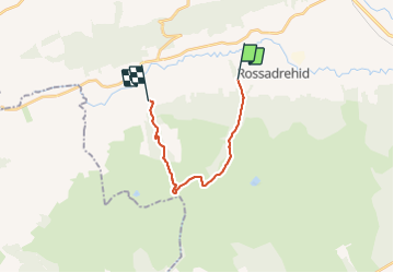

Length
12.6 km

Max alt
591 m

Uphill gradient
546 m
Km-Effort
19.8 km

Min alt
86 m

Downhill gradient
518 m
Boucle
No
Creation date :
2014-12-10 00:00:00.0
Updated on :
2014-12-10 00:00:00.0
--
Difficulty : Unknown

FREE GPS app for hiking
 SityTrail
IGN / Geographical institutes
SityTrail Plus
The world is yours!
About
Trail Walking of 12.6 km to be discovered at Unknown, County Tipperary, The Municipal District of Cahir — Cashel. This trail is proposed by mlmoroneybb.
Description
OPEN MOORE LAND
Positioning
Country:
Ireland
Region :
Unknown
Department/Province :
County Tipperary
Municipality :
The Municipal District of Cahir — Cashel
Location:
Templeneiry
Start:(Dec)
Start:(UTM)
559061 ; 5807311 (29U) N.
Comments